Introduction
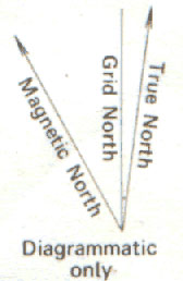
The important thing here is to remember that a compass points not to true north (e.g. the north pole, the geographical northernmost point of the Earth) but to magnetic north (the magnetic north end of the Earth's 'bar magnet'). These two are not in the same position (indeed the position of magnetic north varies with time).
The apparent position of magnetic north will vary according to your location in the world (most importantly your latitude) and you will need to know the difference between these two positions (magnetic and true north) to take an accurate bearing. Information on the deviation between the two will be found on any (Ordnance Survey) map, and should not be assumed as it can vary by a relatively large amount according to your location.
If the deviation is not given you can find it from the Pole Star or by using the watch method to point to north (see Tracking - Direction Finding methods). Then lining up the compass with the grid lines on the map you can discover the variation if there is one.
Important notes on using bearings

- Locate the information on your map that tells you about the local magnetic variation. This can be found in the Key and also on the map itself.
For the time being let us learn how to use the information on the key.
'Different' Norths On a typical Landranger type map the information will look like this:
Difference of true north from grid north at sheet corners
NW corner - 1° 20' (24 mils) E
NE corner - 0° 54' (16 mils) E
SW corner - 1° 19' (23 mils) E
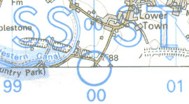
SE corner - 0° 53' (16 mils) EMagnetic north varies with place and time. The direction for the centre of the sheet was about 4 ½° (80 mils) W of grid north in 1990 decreasing by about ½ ° (9 mils) in the next three years.To plot the average direction of magnetic north join the point circled on the south edge of the sheet to the point on the protractor scale on the north edge at the angle estimated for the current year.
Note the last paragraph. This will be explained later.
- To compensate for the angular difference take note of the average variation for the sheet (this is more than acceptable for any sensible work. If you really want to be perfect, take note of the difference between true north and grid north too). In our example sheet above this would give us a value of around 4° (4 ½° - ½° as we are long past 1990). (Note: A difference of 4°, if you walked in a straight line for 10 km would mean you would be around 700m away from your intended destination. So for most everyday uses of bearings the difference is negligible over sensible distances)
- Measure your bearing as you would normally, ignoring magnetic variation.
- When you have your bearing adjust the value by 4°. In our case we would have to ADD 4° to our bearing value to get a 'true-to-life' direction. If the diagram indicated that grid north lay to the left of magnetic north, you would have to subtract the angle from the bearing.
- You can now follow your compass bearing safe in the knowledge that you will be heading in the correct direction.
Note: If you intend to reverse this process...that is to take a bearing from the 'field' and read it back onto the map then you will need to SUBTRACT the 4°.
Plotting Variation on Ordnance Survey Maps


Note the last paragraph in the map extract on magnetic variation above. If you look carefully at your map, at the top and bottom of the map (usually in the centre) will be the information above.
If you draw two lines connecting the circle at the bottom to the two arrows at the top of the map you will have a large version of the diagram in the first table going across your map. This will illustrate how the magnetic variation becomes increasingly important the further the distance you are travelling in a straight line. Imagine travelling 40 km (40 grid squares) along these lines, and then look at how far away from your intended destination you will be (measure 40 km along each line and compare the distance between the two end points). This would be your error if you did not take magnetic variation into account. (On this map the distance is almost exactly 4 km 'as the crow flies') As I have said earlier, if you think about it this is not a great deal (in relation to other errors and considering that we very rarely travel 40 km in a straight line without any checks that is...of course 4 km on its own IS a large error!), and for most situations we do not concern ourselves with this correction, but in some work it may be important, and it may be more important at your location.
Featured Resources
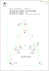
Be sure to check out the excellent resources provided by Graham from the 12th Andover West. The micro navigation resources are work of the highest quality and an incredibly useful tool to help those who are teaching bearings
Featured Resources
Micro Navigation: Bearing resource by Graham Williams, 12th Andover West
